Writing "Alsoomse and Wanchese" -- The Lake That Had Been a Fire
Three months ago (March 2016) I decided that my novel needed
a hostile confrontation between hunters of the central Pamlico Sound Algonquian
mamanatowick Wingina and those of the
upstart weroance of Pomeiooc village, Piemacum, that would worsen relations
between the two feuding leaders. In the novel
I have had Wingina the master of these central North Carolina coastal villages
-- Roanoke, Dasemunkepeuc, Croatoan, Pomeiooc, Aquascogooc, and Secotan – since
1579 (See map: http://homepages.rootsweb.ancestry.com/~jmack/algonqin/feest1.htm) This confrontation is to take place in February
1584. Food is scarce; villagers subsist now
almost entirely on fish and what can be shot with bow and arrow. A large-scale
hunt must be conducted in areas not regularly visited, areas where game has not
been overhunted.
Excerpt:
Wingina
had chosen to split the hunters of the two villages into two groups.
The
Dasemunkepeuc group would paddle into the Great Waters [Albemarle Sound], pass
through the narrow entrance [south of Haulover Point] into the Large Lake [East
Lake], travel beyond where they had hunted during the First Cohonk Moon, and
select one of the marshy peninsulas bordering the Twisted Waters’s [South Lake’s]
six prongs.
The
Roanoke group, eschewing Dasemunkepeuc’s two nearby lengthy creeks [Spencer and
Callaghan Creeks] – would travel a half
day (south) along the marshy coastline to the farthest place where
Dasemunkepeuc and Roanoke braves hunted, a
mostly fresh water lake a short distance inland from a narrow shoreline
of sawgrass, giant cordgrass, and infrequent red cedar. Tales passed down many
generations told of a great fire here [Stumpy Point Bay] that had burned below
the ground for two moons before the gods of fire and water had intervened and
filled the exposed, smoldering hole with underground water.
Deer
and bear were plentiful; but hunting them here would be risky; the Pomeiooc
hunted here also. The Lake
That Had Been a Fire was somewhat closer in distance to Dasemunkepeuc than to
Pomeiooc. Not until Piemacum’s recent
assertion of power had mutual use of the lake been a difficulty.
I needed to do two months of research to determine the
location of this necessary, conflict-generating confrontation for two reasons.
First, the location had to be in disputed territory somewhere
between Pomeiooc and Dasemunkepeuc. Most
of the Pamlico Sound mainland is impenetrable
swamp and pocosin wetland. Fresh water for
deer is plentiful enough in the interior but reaching it and, more especially,
removing slain deer to canoes left at the Pamlico Sound
shoreline would have been extremely difficult. I needed to find navigable streams originating
far enough in the interior where water would be fresh. Searching a coastal map, I found no such
streams emptying into Pamlico Sound until I
reached Pomeiooc-controlled territory.
Second, I found no freshwater ponds or lakes near the salt
or brackish marsh coastline. Here is a
picture of a salt marsh. (http://safeharborenv.com/wp-content/uploads/Image/mmarsh2.jpg) And here a brackish marsh. (http://coastalresilience.org/wp-content/uploads/2014/12/brackishmarsh_AaronMcCall.jpg)
For instance: the lower the marsh, the longer the surface is immersed in tidal waters. Low marshes in
Picture of a brackish marsh:
https://www.fws.gov/uploadedImages/Region_4/NWRS/Zone_3/North_Carolina_Coastal_Plain_Refuge_Complex/Alligator_River/Images/BrackishMarsh-520x289.jpg
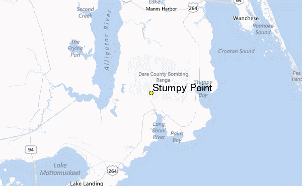
During my research, hoping to find a freshwater source close to the shoreline of Pamlico Sound somewhere between the Algonquian villages Dasemunkepeuc and Pomeiooc, I came upon an article about a once coastal lake formed, possibly, by a forest fire or set deliberately by natives years before 1584, the lake eventually becoming a part of
According to Harold Lee Wise in his book History of Stumpy Point, “John White’s maps of circa 1585 show no indications of Native American settlements there. Still, there is no doubt that Indians, perhaps in their fishing endeavors, were the first to discover the place now called Stumpy Point. The land was part of the Chiefdom of Secotan when Englishmen came to the area in the late 1500s. … At the time,
“A legend arose about the creation of the bay involving the Indians. Lucy Best, a
“It may never be known if there is any truth to this old story. Most likely, it is a Native American legend dating far back in their folklore. Indians told a similar ‘burning out’ story about
Eventually, the lake became part of
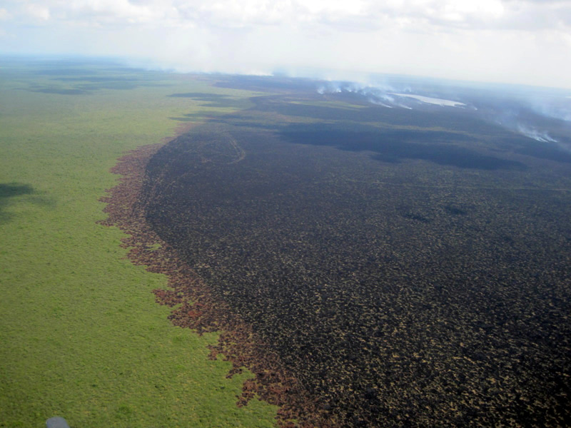
In May 2012, a huge fire consumed thousands of acres of mainland vegetation south of
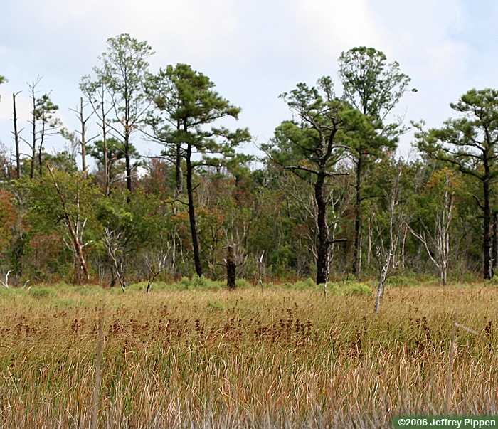
Salt and brackish marshlands eventually become estuarine shrub/scrub land, which can be defined as any shrub/scrub-dominated community subject to occasional flooding by tides, including wind tides. Wax myrtle and eastern red cedar predominate. Downy serviceberry is also present.
Fresh water marshes are found farther inland. They are grassy areas flooded for extended
periods during the growing season.
Included are marshes associated with lakes, managed impoundments, some
Carolina Bays, and other non-tidal marshes.
Vegetation consists of sedges, millets, rushes, grasses, giant cane,
cattail, arrowhead, pickerelweed, arrow arum, and smartweed. Picture: http://www.learnnc.org/lp/editions/cede_wetlands/515
In Alsoomse and
Wanchese I have made the eastern shore of the “lake that had been a fire”
(not yet a part of Stumpy
Point Bay
It
was mid-afternoon when the occupants of the three canoes, rounding the
inward-curving mainland, took their first look at their desired landfall.
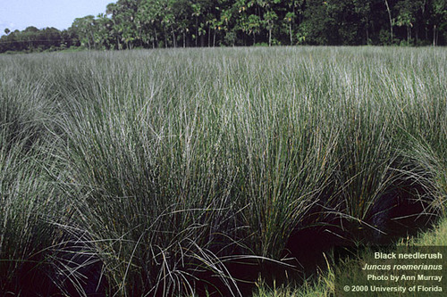
Wanchese, in the third canoe, scanned the shoreline of tall cordgrass and black
needle rush, which they would have to enter, and saw no indication of human
activity. Intent upon the vegetation, he
did not see immediately, as Taraquine did, the irregular column of gray smoke
rising lazily from somewhere behind the hidden lake.
Taraquine’s
curse enlarged his vision.
Pomeiooc
women were cooking. That meant their men had already killed game. How many
sleeps had they been hunting? How much longer would they remain?
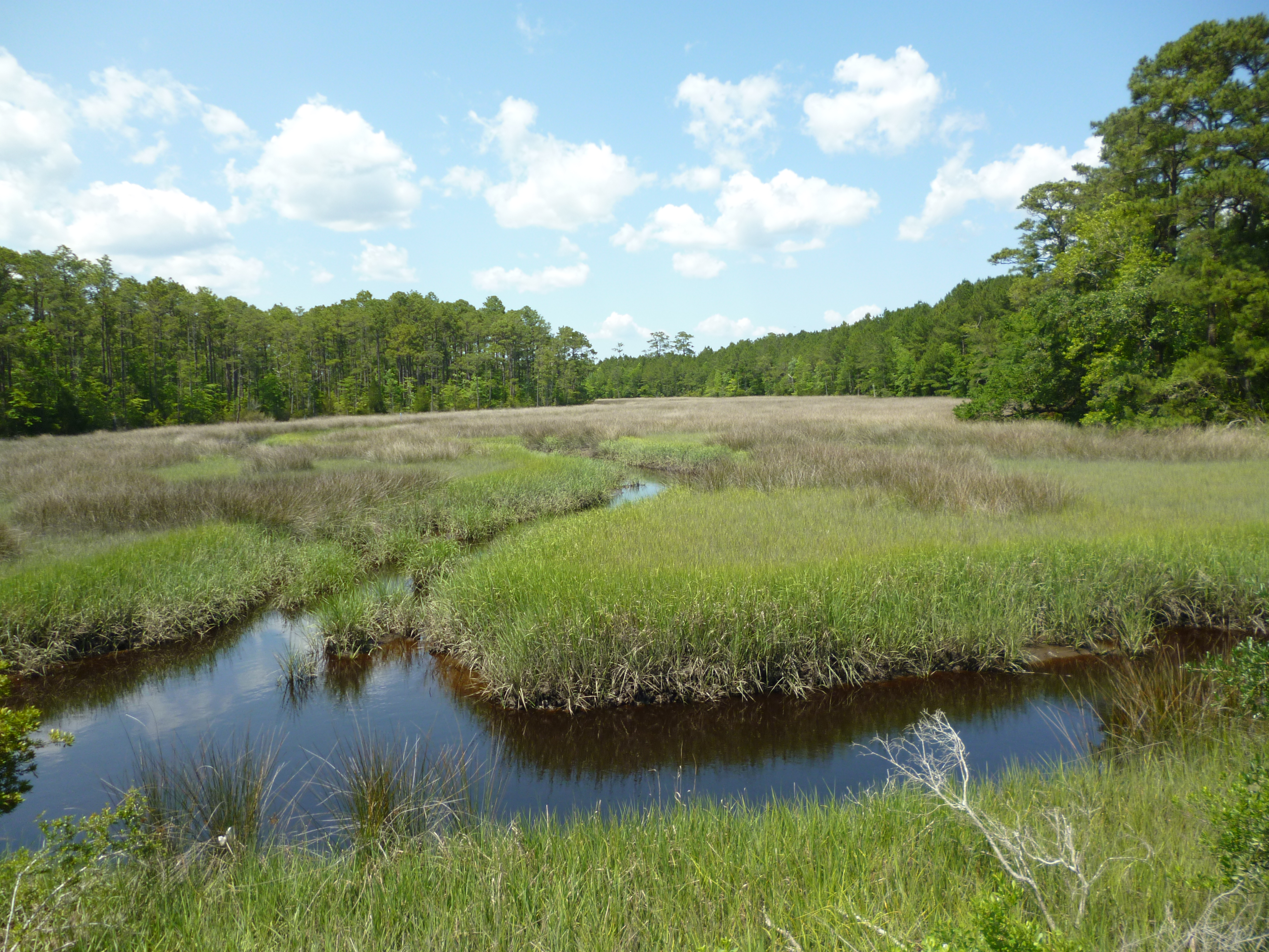
They
had pushed their way through thick cordgrass to feel beneath their feet mucky
ground. Fairly quickly, at the corner of
the lake, far enough away from the ocean water, the salt marsh became wet clay
with needle rush and then saturated, peaty soil, hosting sedges, pickerelweed,
and arrow arum interspersed with serviceberry, red cedar, and wax myrtle. A bit farther ashore, where fresh water from
underground sources fed into the lake, they had come upon the same brushwood
and depressions filled with tall cattails.
To
approach their site, the Pomeiooc would have to travel the ocean facing side of
the lake’s shoreline through cordgrass and needle rush or choose the easier
way, the mainland side, circumventing more conveniently the flesh-slicing
needle rush and colonies of sawgrass.
The women, the two boys, and Huritt’s party were now searching for fuel
for the fire. Tanaquincy had gathered the remaining men about him. Who would wade across the lake to try to
locate in the ocean-facing cordgrass the Pomeiooc canoes?
The
fire, begun during the night, had burned in daylight long enough, in
Tanaquincy’s judgment, to alert the Pomeiooc across the lake. Tanaquincy’s
group, Huritt’s group, and Taraquine and Tihkoosue from Wanchese’s group had
retired into the serviceberry and wax myrtle – the women farther removed – to
wait. Wanchese and Machk had kept expanding the breadth of the raft that
Tanaquincy, Cossine, Mingan, Wanchese, Machk, and Taraquine had constructed
during much of the night. … Machk and he
had laid another relatively straight red cedar limb next to the branches that
had already been tied together. Both he and Machk heard simultaneously the
sound of wax myrtle branches pushed against and snapped back. They rose instantly
from their crouch.
A voice beyond the wax myrtle
reached them. “There are three of us. We come to talk. May we approach?”
Pictures:
http://www.dcr.virginia.gov/natural-heritage/natural-communities/image/pvd-photo-500.jpg
(a maritime shrub swamp
dominated by wax myrtle (Morella cerifera ) and saltmeadow cordgrass (Spartina
patens)
Downy Serviceberry:
Sedges:
Pickerelweed:
Smartweed:
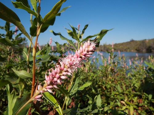
Arrow Arum:
Sawgrass:
Millets:
Cattail:
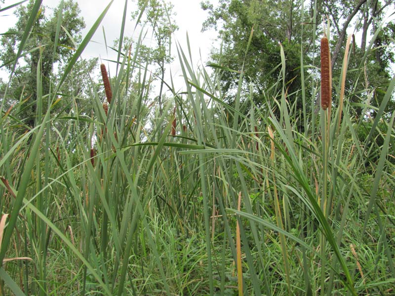
No comments:
Post a Comment